
Maps are key to understanding the Civil War in Missouri. From maps of rail lines to ethnicity, maps can explain history on a human and physical geographic level. Below, is a list of essential maps of Missouri in the mid-19th century. Some are contemporary to the time (or under 10 years after the war), while others are modern.
Note: This is an ongoing project to add new maps, both contemporary and modern.
Contemporary
- Battle Grounds in Missouri During Price’s Raid in the Fall 1864, 1865 (LOC)
- Bellefontaine Cemetery, 1852 (SHSMO)
- Bird’s Eye View Maps of Missouri, c1869 (LOC)
- Colton’s New Map of Missouri, 1851 (LOC)
- Diagram of the State of Missouri, 1852 (SHSMO)
- Lloyd’s Official Map of Missouri, 1861 (LOC)
- Map of the Battlefield Near Belmont, Missouri, 1876 (LOC)
- Map of the City of St. Louis, Mo. and Vicinity, 1853 (SHSMO)
- Map of the Hannibal & St. Joseph Railroad and Its Connections, 1860 (LOC)
- Map of Pettis County, Missouri, 1867 (LOC)
- Map of the Present Seat of War in Missouri, 1862 (LOC)
- Map of Saline County, Missouri, 1871 (LOC)
- Map of the Seat of War in Missouri, 1861 (SHSMO)
- Map Showing the Iowa & Missouri State Line Railroad and Its Connections, 1868 (LOC)
- Map Showing the Pacific Railroad of Missouri, 1865 (LOC)
- New Map of the State of Missouri, 1852 (LOC)
- New Topographical Map of Saint Louis, Missouri, 1857 (LOC)
- Pacific, formerly Franklin, Franklin Co., Missouri, 1869 (LOC)
- Township Map of the State of Missouri, 1858 (SHSMO)
- View of the Slave Population in Several Counties in Missouri (Unknown)
Modern
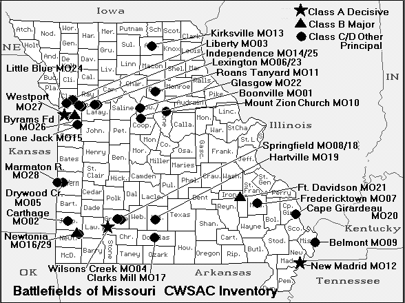
- Battlefields of Missouri (CWSAC)
- Carthage Battle Map (ABT)
- Final Civil War Battles in Missouri Map (STLPD)
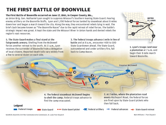
- First Boonville Map (STLPD)
- Wilson’s Creek Battle Map (ABT)
- Wilson’s Creek National Battlefield Map (NPS, WICR)
Index
- ABT: American Battlefield Trust
- CWSAC: Civil War Sites Advisory Committee
- LOC: Library of Congress
- NPS: National Park Service
- SHSMO: The State Historical Society of Missouri
- STLPD: St. Louis Post-Dispatch
- WICR: Wilson’s Creek National Battlefield
